Try to wrap a football in aluminium foil and you will discover that you have to crumple up the foil to make it fit snugly to the ball. In the same way, it is impossible to represent the curved surface of the Earth on a flat plane without some distortion. [See this week’s That’s Maths column (TM068): search for “thatsmaths” at irishtimes.com].
![Mercator projection of the Earth, truncated at 75 degrees North and South [Wikimedia Commons, author: Strebe].](https://thatsmaths.com/wp-content/uploads/2015/05/mercator-projection-75deg.jpg)
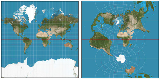
To depict a region on a plane map, we have to project the spherical surface onto the flat plane. Cartographers have devised many projections, each having advantages and drawbacks. No single projection can preserve all properties of the Earth. Some keep areas the same but distort angles, some do the reverse. Some preserve distances, others preserve directions. Some are suitable for polar regions, others for the tropics. No one projection is ideal; there is no perfect map.
One very desirable property of a projection is that of preserving shapes, at least for small regions. If two curves on Earth intersect at a certain angle, the corresponding “image” curves on the map should intersect at the same angle. For example, parallels and meridians are perpendicular on the globe so they should remain so on the map. Projections which are shape-preserving are called conformal. Many popular map projections are conformal.
Navigation Charts
For a sailor plotting a course, it is convenient to maintain a constant direction or compass bearing. Such a course is called a loxodrome or rhumb line. It is not the shortest route between two points (a great circle is) but it makes life easy for the navigator.
In 1569 the Flemish geographer Gerardus Mercator devised a map on which loxodromes appear as straight lines. This map quickly became the standard for nautical purposes. Navigators could now plot a loxodromic course as a straight line joining their departure point and destination, and follow this course across the ocean by maintaining a fixed bearing.
On Mercator’s projection, all parallels of latitude have equal length. Since on Earth their lengths decrease towards the poles, the parallels are stretched on the map. To ensure a conformal projection the north-south spacing between them must also increase with latitude, expanding areas in polar regions. The projection is based on a cylinder tangent to the Earth at the Equator.
In the tropics, the cylinder is close to the Earth’s surface, and an accurate representation results. At high latitudes, the cylinder departs indefinitely far from the Earth: distances and areas are grossly distorted. As a result, Mercator’s map becomes useless at high latitudes due to the excessive distortion.
The Irish National Grid
But take a look at an Ordnance Survey of Ireland ( OSi ) map: it is a Transverse Mercator Projection, based on an Airy modified spheroid. For a regular Mercator map, the cylinder touches the Earth along the Equator. For a transverse projection, the cylinder is turned through a right angle, so it is tangent to the Earth along a meridian of longitude. Therefore, distortion is minimised along this central longitude.
For Ireland, the central meridian is 8 degrees west, a line extending from Horn Head in Donegal, southward through Lough Ree in the centre of Ireland and reaching Ballycotton in east Cork. This is the only meridian that appears as a straight line on the OSi maps. These maps have minimal distortion in the vicinity of Ireland, the region of maximum interest. Mercator’s ingenious invention – so beneficial to the early navigators and explorers – is still a powerful boon to us today.
* * * * * *
 Peter Lynch’s book about walking around the coastal counties of Ireland is now available as an ebook (at a very low price!). For more information and photographs go to http://www.ramblingroundireland.com/
