Recently, I kayaked with two friends on the River Shannon, which flows southward through the centre of Ireland. Starting at Dowra, Co. Cavan, we found it easy paddling until we reached Lough Allen, when the going became very tough. It was an uphill struggle.
Could we really be going uphill while heading downstream? That seems bizarre but, in a certain sense, it is possible.
Forces on the water
Clearly, the water is governed by the pull of the earth and must flow down the gravitational gradient. But the force on the water has two components, Newtonian gravity (

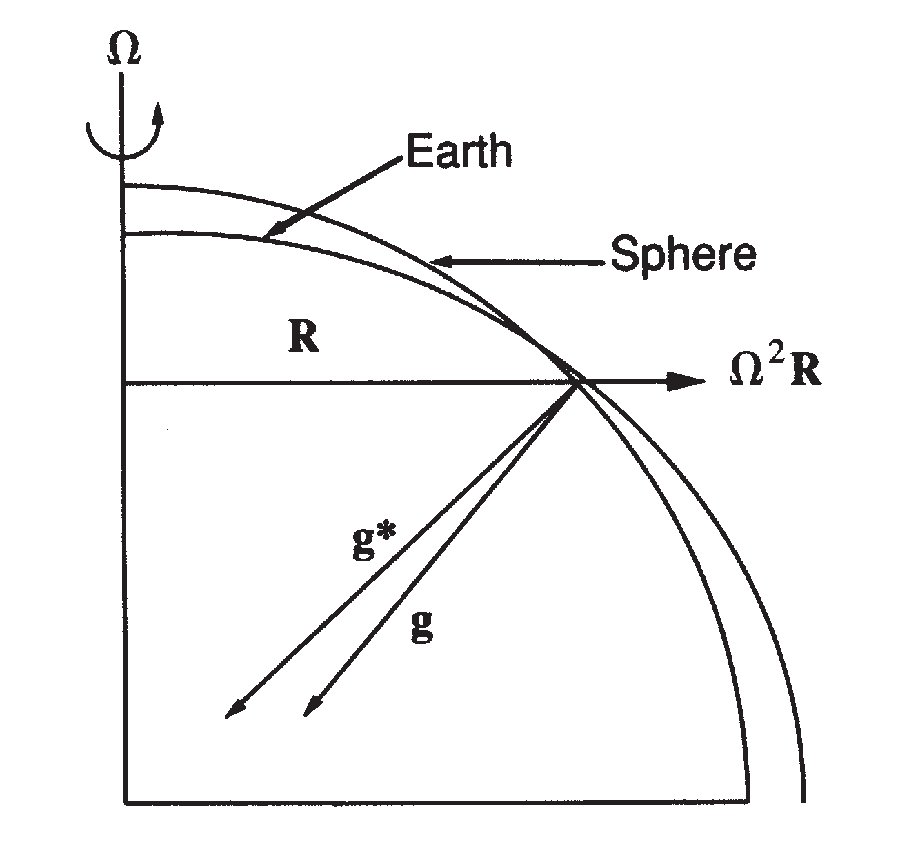
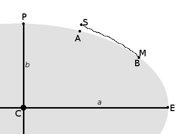
If we slice the earth from pole to pole it has an elliptical form. If there were no land, the ocean surface would have this form. The polar radius — the distance from the earth’s centre to the pole — is about 20km less than the equatorial radius. We show this, greatly exaggerated, in Fig. 2. Points A and B, at different latitudes, are both at sea level. Point A, at higher latitude, is closer than point B to C, the centre of the earth.
We can write the equation for an ellipse as

where 


![\displaystyle r = a[ 1 - f \sin^2\theta ]](https://s0.wp.com/latex.php?latex=%5Cdisplaystyle+r+%3D+a%5B+1+-+f+%5Csin%5E2%5Ctheta+%5D+&bg=ffffff&fg=000000&s=0&c=20201002)
where 


Shannon Waters Rising
The head of Lough Allen is at 


so the change in radius over a span 

Evaluating the sine function at Athlone (latitude 


You may argue that Lough Allen is above sea level. Indeed it is, but only 48 metres. The rise in level from source to mouth due to the flattening of the globe is an order of magnitude larger than the drop due to topography. In Fig. 2, points S and M represent the source and mouth of the Shannon. Despite the elevation of the source, it is closer to the earth’s centre C than is the mouth of the river.
Uphill or Down?
In a physical sense, the water flows downhill, or down the gravitational gradient but, in a geometric sense, it flows uphill: the water at the river mouth is farther from the centre of the earth than is the water at the source. No wonder the going was heavy on Lough Allen.
Sources
For data on the Mississippi and other rivers, see:
♦ Banks, Robert B (1999). Slicing Pizzas, Racing Turtles, and Further Adventures in Applied Mathematics. Princeton Univ. Press, 286pp.
See also several Wikipedia articles: ♦ Figure of the Earth and ♦ Earth Radius
