The idea of using two numbers to identify a position on the Earth’s surface is very old. The Greek astronomer Hipparchus (190–120 BC) was the first to specify location using latitude and longitude. However, while latitude could be measured relatively easily, the accurate determination of longitude was more difficult, especially for sailors out of site of land.
French philosopher, scientist and mathematician René Descartes demonstrated the power of coordinates and his method of algebraic geometry revolutionized mathematics. It had a profound, unifying effect on pure mathematics and greatly increased the ability of maths to model the physical world.
EirCode
EirCodes are the newly-introduced postcodes for addresses in Ireland. About 2.2 million addresses have been given codes. The system has cost €27 million so far, well above €10 per address! Much of the basic information was already available: the source data for EirCode is from An Post’s GeoDirectory and from the Ordnance Survey of Ireland (OSi). EirCodes consist of seven alphanumeric characters, comprising a 3-character routing code and a 4-character random string to pin down the address. There are 139 routing codes covering Ireland.
Many problems with these new codes have been pointed out: EirCode is incompatible with GPS coordinates; it will not work with Sat-Navs and Google Maps. Randomization means codes for adjacent addresses are unrelated. There is no pattern so, for example, collections of addresses on a single street do not form a cohesive set: in effect, Eircode does not recognize streets.
Many commercial transport, mailing and courier companies have said that the new codes provide nothing over and above what is already available and that they will not be using them. This must raise questions about the financial viability of the entire EirCode venture.
Emergency services have complained that EirCode, with its randomization, may endanger lives. A code directly related to the geo-coordinates would enable immediate determination of the location from the code. Is the random component of EirCode designed purely for commercial reasons?
Irish Transverse Mercator (ITM)
A new grid system for Irish mapping was introduced in 2001 by the OSi and the Ordnance Survey of Northern Ireland. The Global Positioning System (GPS) allows anyone with a receiver to obtain their position. It is based on a global reference system, to an accuracy of one metre or better. The older Irish Grid (IG) system was not GPS compatible: GPS coordinates had to be mathematically transformed to fit with IG; this introduced errors.
The new Irish Transverse Mercator (ITM) system is compatible with GPS, benefiting from the accuracy of GPS and minimizing distortions. No transformations are needed to overlay GPS data on ITM maps. ITM is also compatible with the European Terrestrial Reference System (ETRS89).
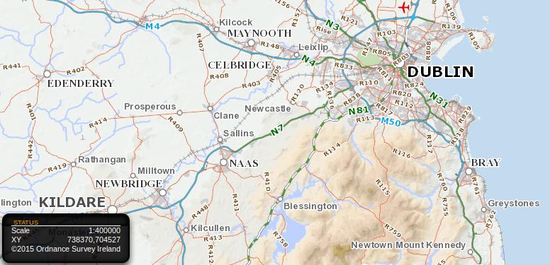
ITM enables every point on the island of Ireland to be specified by giving two six-digit numbers, pinning down the location to a single square metre. It is a simple matter to find this location on a map. The OSi Interactive Map shows the grid coordinates of the cursor position. Moving the cursor to the desired location, the X-Y coordinates can be read off. For example, the coordinates of The Spire in O’Connell Street, Dublin are (715830, 734698).
Why EirCode
If every point down to a resolution of a metre can be indicated by two six-digit numbers, why do we need a post-code such as the controversial EirCode? I do not know!
It can be argued that 12 digits of an ITM grid reference are too many to remember. But who remembers 10-digit phone numbers? Almost no-one: they are stored in our mobile phones, ready for instant use. And who calls out long numbers, to have someone else key them in, with a high risk of error? We just text them!
However, if we really want to have a shorter location code, it is a simple matter to change the number base of the grid reference. Here is how: the coordinates of The Spire are (715830, 734698). In binary code, any number less that a million can be written with 20 binary digits or bits. But 20 is conveniently divisible into five groups of 4 bits. There are 16 possible combinations of four bits: 0000, 0001, 0010, … 1111. Each corresponds to one of the symbols {0, 1, 2, 3, 4, 5, 6, 7, 8, 9, A, B, C, D, E, F}.
Changing the Number Base
Replacing each of the five groups of four bits by one of these symbols, we get the hexadecimal form of the number. For example, the coordinates of The Spire, expanded to binary form, become (1010 1110 1100 0011 0110, 1011 0011 0101 1110 1010). This is 40 bits but, changing to hexadecimal, it reduces to 10 characters (AEC36, B35EA). Thus, we can uniquely specify a location with just 10 alphanumeric characters. (If the elevation is required, it is a simple matter to add a third group giving the altitude).

If that is not good enough, we can move to base-32, using the symbols 0–9 and A–V (or, if I and O are omitted to avoid confusion with 1 and 0, use 0–9 and A–X). In base-32, The Spire is at (LR1M, MDFA); just 8 characters tie down the location to a tiny one-metre square in the heart of Dublin. This is only slightly longer than the EirCode strings, which are seven characters long, but is much more comprehensive, flexible and powerful.
Advantages
A scheme of the type proposed here has many advantages:
-
A unique code identifies locations to an accuracy of a metre.
-
Every street corner, lamp-post, pillar-box, traffic-light, and park bench has a code.
-
Every lay-by, TV mast, pylon, railway bridge, beach-hut and gate-post has a code.
-
The coordinates are continuous in space: adjacent locations have similar coordinates.
-
Both coordinates vary smoothly as we move from place to place: there is no randomness.
-
Conversion between decimal and hexadecimal is a trivial matter for a mobile phone app.
-
The coordinates are meaningful: users can immediately locate positions on a map.
-
Check digits can easily be introduced to increase robustness.
-
The system is completely transparent and entirely cost-free.
More highly-developed location systems based on the above ideas — for example OpenPostcode and Loc8 Code — have been proposed. Why has the cumbersome and expensive EirCode system been chosen?
That’s Not Maths!
* * * * * *
 Peter Lynch’s book about walking around the coastal counties of Ireland is now available as an ebook (at a very low price!). For more information and photographs go to http://www.ramblingroundireland.com/
